The London Topographical Society is probably most familiar
to London archaeologists and historians as the name behind their 'A-Z' seriesof historical map reprints. As well as a 25% reduction on the excellent
historic map series and other publications, LTS members receive at least one new
LTS publication every year; this year it
is 'London Plotted, plans of London buildings c.1450–1720' by Dorian Gerhold,
edited by Sheila O'Connell. The book is a 320 page hardback with colour plates
of 197 detailed plans of London buildings, dating from the relatively well
known plan of The Charterhouse of c.1450 to previously unpublished plans of 17th and 18th century buildings.

 |
| John and Isaac Olley's 1712 plan of houses in The Minories |
As part of LP Archaeology's 100 Minories project I've been
working on George Dance's redevelopment of The Minories c1760, and although his plans fall
outside the date range of this book, Gerhold does include a detailed 1712 plan by
John and Isaac Olley of a mid-17th century brick property on Minories that
would have been demolished to make way for Dance's development.
The planned building is
sadly just north of the LP Archaeology 100 Minories excavations, so it isn't a
building that we excavated, but it does give a very visual indication of the ground
plan, layout and function of the type of buildings we have excavated. The plan
is marked with stairs, cupboards and partitions -with brick and timber/plaster
being differentiated- and the function of each room indicated.
 |
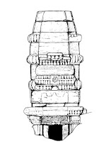
| Mid 17th century brick buildings at 100 Minories |
The value to archaeologists of these historical building plans is immense, especially when they can be tied to excavated buildings and linked with other documentary sources such as leases and probates. In providing a detailed consideration of, and access to, nearly 200 building plans this volume will prove to be a valuable research tool, as well as being an excellent read in itself.
London Plotted: Plans of London Buildings c.1450-1720 by Dorian Gerhold, edited by Sheila O'Connell, Hardback, 320pp, 22 x 30.5 cm. £35


No comments:
Post a Comment